
Stellarium landscapes
One of the great features of Stellarium which contributes a lot to its photorealistic impression is the possibility to embed "real" photographed landscapes into the sky's visual representation. While the Stellarium software package already contains a handful of standard landscapes for direct use, far more have been created in the meanwhile by enthusiasts that are downloadable from the Stellarium site.
Packed to packages and documented like the landscapes featured on the Stellarium website are the following Stellarium landscapes created by myself that are downloadable here. Therefore, installation of these landscapes follows just the same rules and principles as described on the Stellarium website. When clicking on a preview icon a magnified version of the preview will show up in a separate pop-up window.
In order to reveal a visual impression of Stellarium I created two short time-lapse videos using the hi-res variants of Stellarium landscapes "Hildesheim Panoramaweg" (to be found on following platforms: YouTube, Vimeo, dailymotion, Rumble, flickr, Minds, Odysee, VK) and "Altenwalde Heath" (to be found on following platforms: YouTube, Vimeo, dailymotion, Rumble, Minds, Odysee, VK).
For some of the following Stellarium landscapes, I created real-world cylindrical panoramas (with limited range of altitude angle) from the very same photographic material and published them on 360cities.net, the world's largest online collection of geo-referenced panoramas. For these Stellarium landscapes, a 360cities logo appearing in the header of the preview window indicates the availability of a corresponding pano on 360cities.net and links directly to it.
You can learn about how to create such landscapes by yourself on a separate page containing tutorials of my own and links to other tutorials on the web.
Installation of Stellarium landscapes
The Stellarium landscapes presented here were packed to ZIP archives, downloadable by clicking on the landscape's name. They always contain the following files:
- <landscape-name>/description.de.utf8 - landscape description, accessible from within Stellarium via the menus,
- <landscape-name>/description.en.utf8 in German and in English
- <landscape-name>/gazetteer.de.utf8 NEW - Optional landscape labels
- <landscape-name>/gazetteer.en.utf8 NEW in German and in English
- <landscape-name>/landscape.ini - config file, i.a. containing the site's exact geographical coordinates
- <landscape-name>/readme.txt - description and installation guide in English, as readable text file
- <landscape-name>/<landscape-name>.png - the actual image file of the landscape
For system-wide installation in a multiuser environment, unzip the landscape package file in the <config_root>/landscapes directory (e.g. <config_root>=/usr/share/stellarium or similar). For personal installation, use the "Add/Remove Landscapes" dialogue accessible from the "Landscapes" tab of the "View" window to install the packed ZIP file automatically (no manual unzipping needed, Stellarium will do it for you), or unzip the landscape package file in your personal Stellarium landscapes directory (e.g. $HOME/.stellarium/landscapes). File locations may vary depending on your operating system. See the Stellarium User Guide for per-platform details.
Once you have installed the landscape, open Stellarium and go to the "View" window. Select the "Landscapes" tab, and select the landscape from the list of available landscapes.
NEW Gazetteer files (landscape labels) included now! NEW
The landscape labels can be switched on/off by toggling the button "Show landscape labels" within
the "Landscapes" tab of the "View" window. The gazetteer files can be deleted without affecting
the numerous other features of Stellarium.
Gazetteer support in Stellarium started with version 0.14.0.
Stellarium landscapes built from own photographs
| Landscape | Author | Licence | Comp. with | Lang. | |
|---|---|---|---|---|---|
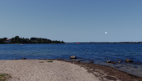 |
Cape Holnis, Flensburg Firth, Germany NEW | Torsten Narjes | CC BY-NC-SA 3.0 | 0.12+ | EN DE Danish |
| This panorama was taken in August 2016 at Cape Holnis, Holnis peninsula at Flensburg Firth (54°52′38.0″N, 9°36′47.4″E). The firth's Danish shore being just 3 km away from the shooting site dominates this panoramic view, furthermore, a stretch of the firth shore of Anglia peninsula can also be seen. Også på dansk! File size: 9.3 MB. Resolution: 4096x2048 pixels. Also available in higher resolutions 8192x4096 (36.6 MB) and 16k old style (115.6 MB). |
|||||
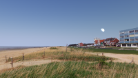 |
Sahlenburg Beach, Cuxhaven, Germany | Torsten Narjes | CC BY-NC-SA 3.0 | 0.12+ | English German |
| This panorama was taken in April 2014 in Cuxhaven at Sahlenburg Beach, beach access point Wernerwaldstrasse (53°51′33.5″N, 8°35′22.3″E). Cuxhaven is a well-known seaside resort and harbour town in northern Germany. The Wernerwald forest (SE) is visible, as well as the Wadden Sea with the Isle of Neuwerk (NW). File size: 10.9 MB. Resolution: 4096x2048 pixels. | |||||
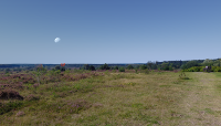 |
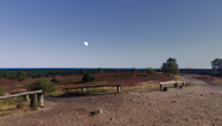
Altenwalde Heath, Cuxhaven, Germany | Torsten Narjes | CC BY-NC-SA 3.0 | 0.12+ | English German |
| This panorama was taken in August 2017 in Cuxhaven at the northern edge of Altenwalde Heath near the Feldherrnhuegel (53°50′02.8″N, 8°38′33.6″E). The former military training area became the core of the nature reserve "Cuxhavener Küstenheiden". File size: 10.3 MB. Resolution: 4096x2048 pixels. Also available in higher resolutions 8192x4096 (41.1 MB) and 16k old style (127.1 MB). | |||||
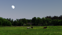 |
Seppensen, Buchholz in der Nordheide, Germany | Torsten Narjes | CC BY-NC-SA 3.0 | 0.12+ | English German |
| This panorama was taken in May 2014 on a meadow between the Distelweg football playground and the horse pasture at Thomasfeldweg in Buchholz-Seppensen (53°18′11.5″N, 9°51′54.9″E). Seppensen is a rural part of Buchholz, a 40,000-inhabitant town in the German state of Lower Saxony approximately 30 km SW of Hamburg. File size: 11.4 MB. Resolution: 4096x2048 pixels. | |||||
 |
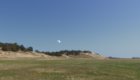
Brunsberg, Buchholz in der Nordheide, Germany | Torsten Narjes | CC BY-NC-SA 3.0 | 0.12+ | English German |
| This panorama was taken in September 2014 - at the peak of heather flowering season - on Brunsberg hill (129 m above sea level) in Buchholz i.d.N. on the NW edge of Lueneburg Heath (53°18′01.0″N, 9°49′55.7″E). Brunsberg hill offers nearly a 360° view over large parts of the western Nordheide including Wilseder Berg hill (169 m), the highest elevation in the NW German lowlands. File size: 10.0 MB. Resolution: 4096x2048 pixels. | |||||
 |
Schmoelen Dune, Doemitz (Elbe), Germany | Torsten Narjes | CC BY-NC-SA 3.0 | 0.12+ | English German |
| This panorama was taken in April 2015 on the windward side of Schmoelen Dune in the Loecknitz/Elbe valley near Doemitz (53°07′25.0″N, 11°17′34.1″E). With its size of 2 km in length, 600 m in width, and a height of more than 30 m above ground level, Schmoelen Dune is Europe's largest inland dune. File size: 12.7 MB. Resolution: 4096x2048 pixels. | |||||
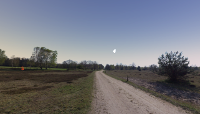 |
Tuetsberg West, Lueneburg Heath, Germany | Torsten Narjes | CC BY-NC-SA 3.0 | 0.12+ | English German |
| This panorama was taken in April 2014 on the western "slope" of Tuetsberg hill (117 m), located in one of the major central heathland stretches of Lueneburg Heath national park (53°07′09.4″N, 9°53′51.0″E). File size: 11.1 MB. Resolution: 4096x2048 pixels. | |||||
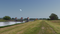 |
Gnevsdorf Weir, Prignitz, Germany | Torsten Narjes | CC BY-NC-SA 3.0 | 0.12+ | English German |
| This panorama was taken in May 2014 on the Gnevsdorf Weir island (52°54′25.5″N, 11°53′00.0″E) at the confluence point of rivers Elbe and Havel (Gnevsdorfer Vorfluter) in Gnevsdorf near Rühstädt, a village famous for its large population of breeding white storks during spring and summer. File size: 10.3 MB. Resolution: 4096x2048 pixels. | |||||
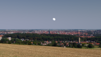 |
Hildesheim Panoramaweg, Germany | Torsten Narjes | CC BY-NC-SA 3.0 | 0.12+ | English German |
| This panorama was taken in August 2016 on Panoramaweg road at Rottsberg hill in Hildesheim, about 3 km west of the city centre
(52°08′11.3″N, 9°54′44.5″E).
The photo shooting site, located 115 m above the Hildesheimer Börde lowlands, offers an
outstanding view upon nearly the whole city. File size: 10.7 MB. Resolution: 4096x2048 pixels. Also available in higher resolutions 8192x4096 (38.6 MB) and 16k old style (123.1 MB). |
|||||